

Philippines Cube Satellites

The Philippines has recognized the importance of space for the development of the nation. That is why on the 8th of August 2019, former President Rodrigo R. Duterte signed into law Republic Act (RA) No. 11363. The law is “An Act Establishing the Philippine Space Development and Utilization Policy and Creating The Philippine Space Agency, and for Other Purposes,”.
Most will know this law as the Philippine Space Act. Consequently, this created the Philippine Space Agency (PhilSA). The agency under R.A. 11363 shall be the central government agency under the executive committee. They are to address all national issues and activities related to space science and technology applications.
Benefits of Having Satellites

Because of this, PhilSA has made great strides to advance the Philippines’ space capabilities. Praise-worthy accomplishments of PhilSA are its cube satellites or microsatellites. PhilSA has built and launched satellites into Earth’s orbit with the help of other partnered space agencies. These are small satellites. For that reason, PhilSA built their satellites to have dimensions that would range from 10 or 15-centimeter cubes. As such, the dimensions result in satellites weighing 1 to 57 kilograms. Moreover, PhilSA installed sensors on the satellites to observe the Philippines from space. Thus making their satellites cheap to produce, maintain, and launch into orbit.
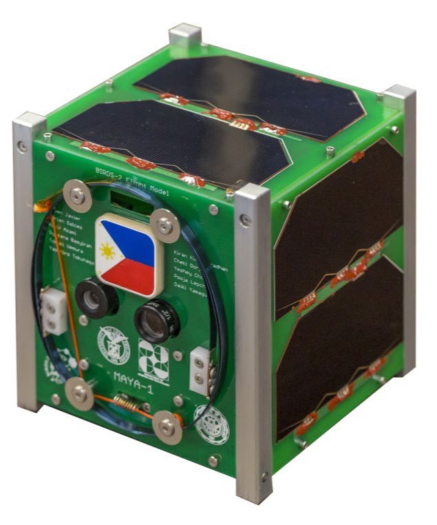
PhilSA has many satellites in orbit like Diwata-1 and 2. Notably, Diwata one was the first Filipino-built satellite under the Development of Philippine Scientific Earth Observation Microsatellite (PHL-Microsat). And recently, they launched their first cube satellite (CubeSat) developed by Filipino engineers through the PHL-Microsat Program. PhilSA gave the name Maya-1 to their first CubeSat. But, PhilSA still uses foreign satellites to supplement some of its capabilities. But beyond that, what are the benefits of having satellites? Well, here are five benefits of having satellites.
1. Natural and Built Environment Monitoring
Because of the satellites being able to orbit around Earth. It can see the Philippines from a whole different perspective. First, PhilSA can monitor the effects of growing urban sprawl on the environment. Now PhilSA and other related government agencies can more efficiently study pollution caused by urbanization. Or they can see patterns of how urban sprawls in the country are developing. In addition, satellites can help people with navigation by detecting road network changes. The Filipino people can now better manage the development of urban areas without compromising the environment.
2. Agriculture, Fisheries, and Resource Management
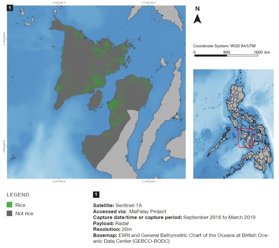
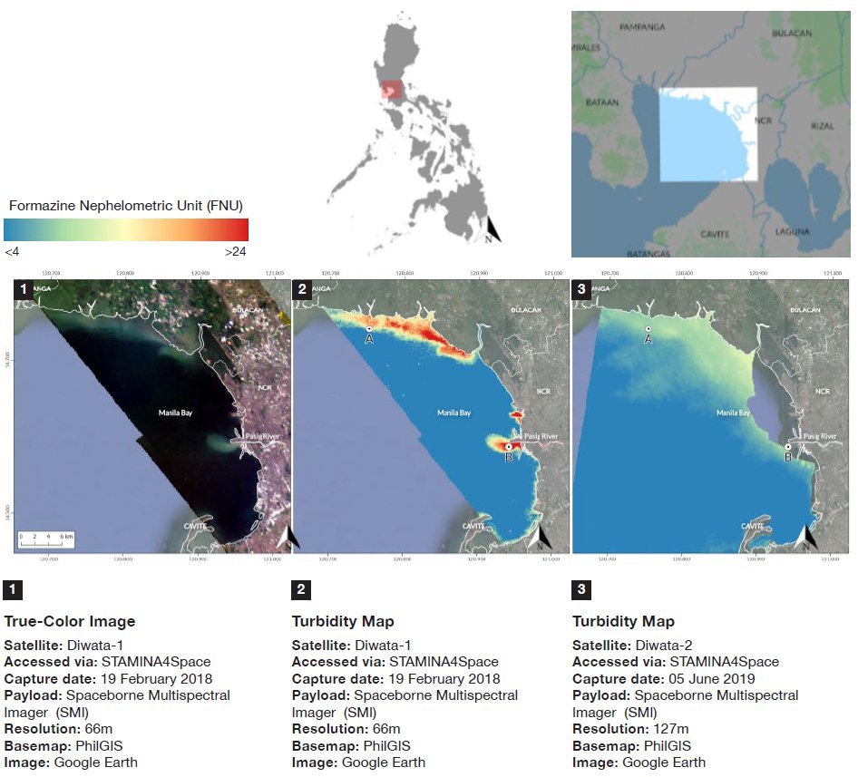
Monitoring large hectares of farmland and fisheries is difficult. Especially, when the Philippines is an archipelago nation. Now with the use of satellites, we are more able to detect threats to our agricultural sector and fisheries. PhilSA can now easily monitor water levels in dams. In addition, the satellites in orbit can spot early signs of droughts. Lastly, these satellites produce mapping crops that can help with crop management. While on water, PhilSA can monitor signs of fish kills and water pollution.
3. Disaster Risk Management
Next is the most common advantage of satellites, disaster management. Because of PhilSA’s satellites, the Philippine government can better prepare for disasters. These machines can track storms and typhoons which can warn potentially affected areas to evacuate. Because of this, PhilSA can now easily assess the damages caused and have plans to mitigate its effects after a calamity strikes.

4. Defense and Security
The Philippines does not have enough people and ships to protect its waters. Thus, PhilSA can help by being a complementary maritime surveillance and monitoring system for the National Coast Watch. Furthermore, PhilSA is developing a prototype damage detection using Artificial Intelligence (AI) in Marawi City. This can greatly improve the speed of Marawi City’s rehabilitation by mapping out all damaged areas.
5. Planning and Econometrics
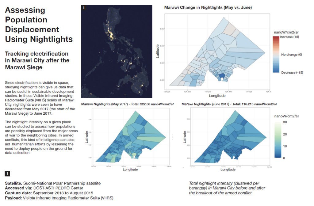
Lastly, we can better plan for the future by using PhilSA’s satellites. Look back at the amount of information these satellites can get. Developers and planners can use this as a basis for their fundamental understanding of what and how to build things. Looking at night light intensity is a great example. PhilSA found signs of population displacement through the observation of the night light intensity of an area. And also, this observation can show areas with high amounts of poverty. Because of this, planners and developers can help these areas by knowing where they are and what they need based on satellite imagery.
Brighter Future

Currently, PhilSA is developing a more advanced satellite to launch into orbit. They will be replacing the older ones like Diwata 1 & 2 and Maya 1. Also, this will expand the coverage to more areas to help more people. Because of the PhilSA efforts, the Philippines has a bright future amongst the stars.

