

TAAL VOLCANO: What do the alert levels mean?

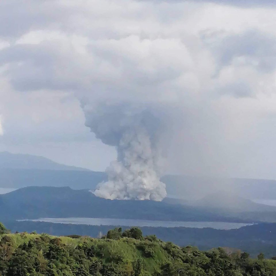
Since yesterday, the Taal Volcano has been spewing ashes at the diameter it reaches. As of Monday, January 13, ‘weak’ lava fountains also emerged in the early hours of the morning accompanied by thunder and flashes of lightning. On Sunday, January 12, Philippine Institute of Volcanology and Seismology (Phivolcs) raised Alert Level 4, warning citizens about an imminent hazardous eruption.
With Taal Volcano at Alert Level 4, here’s what you should know about volcano alert levels:
Alert Level 0: Quiet or no alert.
All monitored parameters within background levels. Unremarkable level of volcanic earthquakes occurring within the volcano area. Generally weak steam emission.
Quiescence; no magmatic eruption is foreseen. However, hazards like explosions, rockfalls and landslides may suddenly occur within the four-kilometer radius Permanent Danger Zone (PDZ).
Alert Level 1: Low Level of Volcanic Unrest
Slight increase in volcanic earthquake and steam/gas activity. Sporadic explosions from existing or new vents. This also includes notable increase in the temperature of hot springs. Slight inflation or swelling of the edifice.
Hydrothermal, magmatic, or tectonic disturbances. The source of activity is shallow, near crater or in the vicinity of Irosin Caldera. Entry into the PDZ must be prohibited.
Alert Level 2: Moderate Level of Volcanic Unrest
Elevated levels of any of the following: volcanic earthquake, steam/gas emission, ground deformation and hot spring temperature. Intermittent steam/ash explosion and above baseline Sulfur Dioxide2 emission rates. Increased swelling of volcanic edifice.
The alert for Taal Volcano raised to Level 2 on Sunday, January 12 at 2:30 in the afternoon. This, then, happened due to a stream-driven episode that occurred when magma, lava, hot rocks and/or new volcanic deposits heated the water beneath the ground.
Alert Level 3: High Level of Volcanic Unrest.
Sustained increases in the levels of volcanic earthquakes, some may be perceptible. Occurrence of low-frequency earthquakes, volcanic tremor, rumbling sounds. Forceful and voluminous steam/ash ejections. Sustained increases in SO2 emission rates, ground deformation/swelling of the edifice.
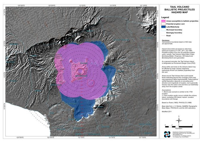
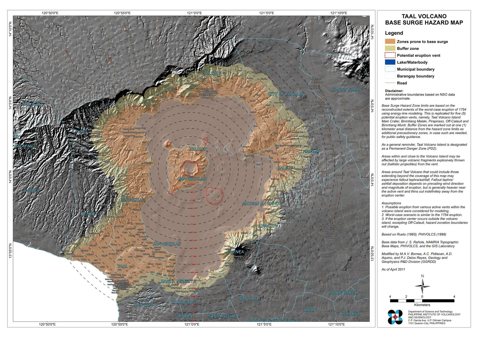
Activity at the summit may also involve dome growth and/or lava flow, resultant rockfall. Magma is near or at the surface, and activity could lead to hazardous eruption in weeks. Then, danger zones may be expanded up to eight (8) kilometers from the active crater.
The alert for Taal Volcano raised to Level 3 on Sunday, January 12 at four in the afternoon. This happened due to volcanic tremors and earthquakes in Volcano Island which also includes barangays in Agoncillo, Batangas. Aside from that, ashfall also became present at the southwest of Taal.
At this level, Phivolcs has strongly recommended the evacuation of Taal Volcano Island and the high-risk barangays in Batangas. They also recommend this due to the possible hazards of pyroclasic density currents. This includes flows of hot gas, ash and rocks that could rush down from volcanic slopes. Aside from that, volcanic tsunami can also occur.
Alert Level 4: Hazardous Eruption Imminent.
Intensifying unrest characterized by earthquake swarms and volcanic tremor, many perceptible. This also includes frequent strong ash explosions. Sustained increase, or sudden drop, of SO2 emission. Increasing rates of ground deformation and swelling of the edifice.
Lava dome growth and/or lava flow increases, with increased frequency and volume of rockfall. Magmatic processes or effusive eruption underway, which can progress into highly hazardous eruption. Danger Zone may be extended up to nine (9) kilometers or more from the active crater.
The alert level for Taal Volcano raised to Level 4 on Sunday, January 12 at 7:30 in the evening. This happened due to two volcanic earthquakes of magnitudes 2.5 and 3.9 at Intensity III in Tagaytay City and Alitagtag, Batangas respectively. At this level, a hazardous eruption could happen within days.
The Civil Aviation Authority of the Philippines (CAAP) has already instructed aircrafts to avoid airspace around Taal Volcano. They did so due to airborne ash and ballistic fragments that could cause hazards to an aircraft. The CAAP also said that they have suspended arriving flights beginning Sunday, January 12 at 7PM. Meanwhile, they suspended departing flights at 6:20PM onwards.

Alert Level 5: Hazardous eruption in progress.
Magmatic eruption characterized by explosive production of tall ash-laden eruption columns, or by massive collapses of summit lava dome. Generation of deadly pyroclastic flows, surges and/or lateral blasts and widespread ashfall. Life-threatening eruption producing volcanic hazards that endanger communities. Additional danger areas may be declared as eruption progresses.
TAAL VOLCANO UPDATES:
As of this writing, the Taal Volcano has spewed lava fountains amid the threat of hazardous eruption. The Phivolcs issued a bulletin at eight in the morning.
“This magmatic eruption is characterized by weak lava fountaining accompanied by thunder and flashes of lightning.”
They recorded the magmatic eruption at 2:49 to 4:28 in the morning of Monday, January 13. This came after stream-driven eruption in several points inside the volcano’s main crated had begun. As of five in the morning, the organization recorded a total of 75 volcanic earthquakes in the area.
Phivolcs, then, recorded the 32 of these earthquakes with the intensities ranging from Intensity II to V in Tagaytay City, Cabuyao City, Laguna; and Talisay, Alitagtag, Lemery and Bauan in Batangas.
“Such intense seismic activity probably signifies continuous magmatic intrusion beneath the Taal edifice, which may lead to further eruptive activity.”
Aside from Batangas, ashfall has also spread in other parts of Calabarzon region, as well as Metro Manila and Central Luzon.

